
|
|
Habib Abi-RachedPh.D in Computer graphics / vision. (Robotics).Habib Abi Rached is a computer scientist and electrical engineer interested in computer vision and graphics. Starting his studies in Lebanon, he completed his bachelor degree in electrical engineering at the Lebanese University. He was awarded a masters degree in computer science from France where he obtained also a DEA in computer science from the ENSEEIHT -Toulouse. After 2 years of research at the Computer Engineering & Science department of the University of Washington., he started a Ph.D journey at the Electrical Engineering Departement of the University of Washington. working at the Human Interface Technology the HITLab- Seattle. |
|
|
|
- Ph.D Grad Student at the Department of Electrical Engineering of the University of Washington.
- Teacher Assistant at the Departement of Electrical Engineering of the University of Washington.
- Teacher Assistant at the Departement of Computer Science of the University of Washington.
Research Topics I am involved in:
Summary:
For a Mars rover capable of long-range mobility, it is highly desirable to
travel to science targets observed in orbital or descent imagery. However,
current rover technologies do not allow rovers to autonomously navigate to
distant targets with a single command. Since communication with Mars rovers
usually occurs only once per day, navigation errors can result in the loss of
an entire day of scientific activity. In order to improve long-range navigation
capabilities, we will map the traverse and target locations using 3D data
generated from all available images, including surface images from the lander
and/or rover, descent images from the lander, and orbital images from current
and future Mars orbiters. LIDAR range data from rovers and/or landers can also
be integrated with this methodology. Initial mapping with descent and orbital
images will occur on the ground and maps will be uplinked to the rover. The
rover will perform additional mapping using conventional and wide-baseline
stereo techniques to generate high-resolution local maps. This will allow
on-board localization of the rover position with respect to the descent and
orbital image landmarks. In addition to improving rover localization
capabilities, the maps will be useful for planning and visualization for ground
operations.
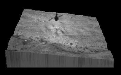
Previous
results:
In previous work, we have generated terrain maps from descent imagery and
combined them in a multi-resolution map structure:
Hand-Gesture
Recognition for HCI
The
goal of this project is to develop a system to recognize hand gestures from
real-time video images, even in the case of occlusion.
Contacts:
Habib Abi-Rached, habib@hitl.washington.edu
- My resume (CV).
- To my familly .